


This article was published on: 02/28/22 11:15 AM
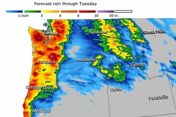
A category 4 out of 5 atmospheric rivers is forecast to bring heavy rain, river flooding, and snow to the Pacific Northwest early this week.
On the atmospheric river scale, category 4 is characterized by “mostly hazardous” but also “beneficial” in terms of the amount of rain expected, according to the Center for Western Water and Weather Extremes (CW3E).
Atmospheric rivers can be both good and bad. On the good side, they are the main contributor to the West Coast water supply, however, they are also the source for the region’s most impactful flooding events.
And this week is no exception in terms of heavy rain and flooding across Washington and Oregon.
“Starting late Sunday night a strong atmospheric river will spread into western Washington and far northwest Oregon,” the National Weather Service (NWS) office in Portland, Oregon, said.
The heaviest rain is expected on Monday through Tuesday morning, with 24-hour rainfall totals of 3 to 6 inches forecast along portions of the Washington and Oregon coasts. Isolated higher rainfall amounts are possible across portions of the Cascades during this same time span.
This heavy rain event is coming off of a relatively dry start to February. As of Sunday morning, the Seattle-Tacoma airport had only received just over 1 inch of rain this month, which is more than a 2.5-inch deficit for the month of February.
While the mountains will first experience snow, temperatures will slowly rise through the higher elevations, leading to a changeover to rain. As this transition occurs rain will lead to additional snowmelt which could cause flash flooding and river flooding over the next few days.