


This article was published on: 06/18/23 3:13 PM
In the wake of several years of below-average snowfall and persistent “exceptional drought” classifications, Central Oregon is back to experiencing a typical snowpack (compared to historic records). However, despite being a “normal” snowpack year throughout the region, the resulting streamflows we witness can vary tremendously depending on the watershed we are looking at. The response to melting snow in the Upper Deschutes and Crooked River Basin presents contrasting scenarios that offer a deeper understanding of how varying geological characteristics can affect the water cycle.
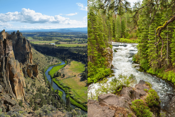
The Crooked River Scenario
Within a span of just three weeks, the near-empty Prineville Reservoir went from roughly 22% capacity to completely full for the first time since 2019. Prompted by early warm weather, water from rapidly melting snow from the Ochocos flowed down the mountains, through the river channels, and into the reservoir. Typical of many western watersheds, the hydrology of the Crooked River is dependent on high streamflow peaks in spring driven by snowmelt running over the landscape to the rivers, lakes, and reservoirs rather than draining into the ground.
In the Crooked River, this surface runoff has crucial implications for both the river’s ecosystem and local farmers. A full reservoir provides water for local farmers, while also allowing for instream flows to be sustained in the Crooked River below Prineville Reservoir to support fish and other aquatic species. Thanks to non-drought year agreements between the irrigation districts and the DRC, a minimum flow of 70 cubic feet per second (CFS) will be maintained upstream of Smith Rock State Park, a considerable improvement from last summer’s low of 10 cfs. For farmers dependent on the Ochoco Irrigation District, water supplies are greatly improved over last year.
The Upper Deschutes River Scenario
Despite experiencing the same “exceptional drought” period and winter snowfall, the Upper Deschutes Basin reacts differently from the Crooked River Basin. The Upper Deschutes, similar to a dry sponge, readily absorbs any available moisture. Unlike the Crooked River which relies on spring surface runoff, the Upper Deschutes’ hydrology is influenced by the interaction between groundwater and springs contributing from beneath.
Unlike the Prineville Reservoir, Wickiup Reservoir (in the Deschutes headwaters), will require several more years of average or above-average snowfall to counterbalance the impact of prolonged drought. Because the discharge of water via groundwater and springs in the Upper Deschutes is delayed over time, the recovery of flows and filling of reservoirs does not immediately follow a good snowpack year. Springs in the Upper Deschutes basin are discharging at historically low rates, revealing the lasting impact of several years of drought on groundwater. While the 2022-2023 snowpack was much needed and welcome, the porous “sponge-like” geology and groundwater connectivity in the Upper Deschutes mean that the Deschutes River will not see the same relief as the Crooked River and will continue to have impacts on fish and wildlife, downstream water availability for farmers, and river-related recreation opportunities. In the meantime, the Deschutes River Conservancy continues to seek improvements to improve water management across the basin and build a more resilient system to better maintain healthy flows year after year.