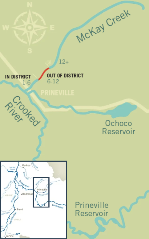
McKay Creek

Restoring McKay Creek's Natural Flows
McKay Creek flows 37 miles from its headwaters in the Ochoco National Forest, through private agricultural land, and joins the Crooked River northwest of Prineville in Crook County. Once a prolific steelhead spawning stream, this Deschutes Basin tributary has been dramatically altered by irrigation. The dominant private land use along the creek is livestock grazing and irrigated forage production that uses water diverted directly from the McKay Creek for approximately 6 miles, resulting in un-naturally low or intermittent flows that limit fish movement and degrades aquatic habitat.
Critical to Steelhead Reintroduction
Since 2007, Portland General Electric and the Confederated Tribes of Warm Springs have reintroduced anadromous fish above the Pelton Round Butte dam complex, restoring salmon and steelhead runs central to the Tribes' culture and way of life. As steelhead return once more to the Upper Deschutes Basin to spawn, many find their way to a still dewatered McKay Creek. Restoring flow to this tributary is a critical piece of the cultural and ecological reintroduction effort.

The McKay Creek Water Rights Switch
The Switch is a voluntary program to restore natural flow to the middle reach of McKay Creek. DRC is working with regional partners and the 14 landowners between river miles 6 and 12 to trade their private McKay Creek water rights for Ochoco Irrigation District (OID) water, delivered from Prineville Reservoir. In exchange, their certified rights, totaling 11.2 cfs, will be transferred instream to support fish and habitat.
Restoring natural flow in this reach addresses several problems at once: low flow, habitat degradation, high water temperature, and impaired fish passage.
What this project means for the people and the river involved:
- Landowners - The opportunity to hold more reliable water rights, providing more water in dry years, plus a potential increase in property value tied to that reliability
- Fish - Extended late spring streamflow that helps steelhead grow from fry to juveniles, plus cooler summer temperatures that improve fry and juvenile survival before they migrate to late-summer rearing habitat
- Ochoco Irrigation District - Stability to their assessment base for potential future urbanization, by adding patrons
McKay Creek's Missing Link
McKay Creek's middle reach sits between two very different stretches of river.
In District (river miles 1–6): Water users here are OID patrons served by Prineville Reservoir. This reach does not experience low streamflows, in part because of the OID water added and the return of irrigation water to the creek.
Out of District (river miles 6–12): Water users divert directly from McKay Creek, contributing to critically low and intermittent streamflow earlier in the summer than would naturally occur. These diversions create fish passage barriers and contribute to high stream temperatures and degraded habitat.
Part of a Bigger Picture (river miles 0–12): Removing all private irrigation diversions from McKay Creek eliminates the diversion structures that block fish passage, and it opens the door to further habitat restoration and land conservation.
The Switch is designed to leverage work already underway:
- It protects water restored to McKay Creek by U.S. Forest Service floodplain restoration projects upstream.
- It opens the door to riparian land conservation with the Deschutes Land Trust and habitat restoration with the Crooked River Watershed Council, both partners with DRC.
- It supports basin-wide efforts by Portland General Electric and the Confederated Tribes of Warm Springs to reestablish anadromous fish species above the Pelton Round Butte dam complex, restoring salmon and steelhead runs central to the Tribes’ culture and way of life.